
Area Info for South Stillwater County
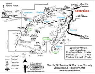
Click for the full-size map
|
Recreational opportunities abound in south Stillwater County. Check out our guide to the best fishing, camping and hiking this area has to offer! |
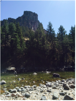 Castle Rock
Local Fishing Access Sites on the Stillwater River
There are some beautiful fishing sites between Absarokee and Nye, Montana. Fishing licenses are available locally at Rockin' J and the Fishtail General Store.
Many Fish Wildlife and Parks Fishing accesses have no fee primitive camping. See the listing below for campsite info. Most of the Following information can be found on the Montana Fish Wildlife & Parks page: http://fwp.mt.gov/fishing/searchFas.html
Absaroka:
1 mile west of Absarokee on Hwy 420, turn north onto Johnson Bridge 0.4 miles, then right on N. Stillwater Road after crossing the bridge. Small area, used for floater put in and take out. Two locations including small parking area 50 yards downstream of main site. (No Camping.)
Cliff Swallow:
9 miles west of Absarokee on Hwy 420. Handicap parking, fishing pier and sidewalk to toilet. Fishing (Handicap Fishing Pier), Camping, Boating – Non Motor (Primitive Launch), Primitive Campsite, Toilet, Easy Accessibility.
Castle Rock: (2017-Must access north from Nye.)
15 miles west of Absarokee on Hwy 420. Spectacular scenery. Handicap parking and sidewalk to latrine. Fishing, Camping, Boat Launch – Non Motor (Primitive Launch), Primitive Campsite, Toilet, Easy Accessibility.
Moraine: (2017 – Must access north from Nye)
16.1 miles west of Absarokee on Hwy 420. Fishing, Camping, Boat Launch – Non Motor (Primitive Launch), Primitive Campsite, Toilet, No Water, Difficult Accessibility.
Buffalo Jump:
Off Highway 419 @ Nye. Fishing, Camping, Boat Launch – Non Motor (Primitive Launch), Primitive Campsite. Toilet, (No Water, Waste Dump), Moderate Accessibility.
Old Nye:
This is a Forest Service access rather than a Fish Wildlife and Parks Access. It is located about 5 miles south of Nye on Highway 419. Day use, Picnic Area, Parking & Toilet.
Fishing Access Site on the West Fork of Stillwater
State Land
Located 1.5 miles from Nye on the West Fork Stillwater Road. Regulated by the Montana Fish Wildlife and Parks for the State of Montana, DNRC, this access is a 2 day stay limit. A Recreational Use License is required. (Hunters and Fishermen are covered to stay at this site thru their conservation license.) Families have the option to purchase a Recreational Use License (State Land Use Permit) for $20 anywhere fishing or hunting licenses are sold. Recreational Use Licenses allow use of other state lands as well. Primitive Camping. No Water, No Toilets.
Fishing Access Site on the West Rosebud River
Rosebud Isle Access
This Fish Wildlife and Parks fishing access is found by driving down the lane between Potter’s Rock Shop and the Fishtail Post Office. It will seem as though private land is being crossed, but there is most assuredly permission to travel down this road to the access. Fishing, Camping (Primitive & No Fee), Toilets, No Water, Moderate Accessibility.
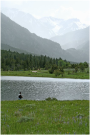 Emerald Lake in June
Lake Fishing
Emerald Lake
28.5 acres, 7 feet deep, elevation 6,310 ft.
Mosquitoes are likely. Bring repellant. Fishing: (Requires Montana Fishing License) Species: rainbow trout (bulk of catch), brookies, browns and occasional cutthroat. Beautiful Alpine lake with easy access. Pine Grove campground is located on the North end of the lake and Emerald Lake Campground on the South.
West Rosebud Lake (1 mile from Emerald)
19 acres, 6+ feet deep, elevation 6,387 ft.
See fishing for Emerald Lake. 8-12 inch fish in WR lake. Access to lake is slightly less due to shallow and marshy areas. An outlet regulating dam is located at the NE end of the lake. Toilet available.
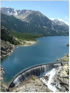 Mystic Lake and Dam
Popular Hikes
Mystic Lake Trail
435 acres, 205+ ft deep, elevation 7,683 ft.
Fishing: Mostly rainbow trout with some rainbow-cutthroat hybrids. Occasional cutthroat.
From the start, Mystic Lake Trail meanders a couple miles along a Lodge Pole Pine-shaded trail adjacent to the West Fork of the Rosebud River. Trail length is 7 miles round trip with a 1,200 foot elevation gain. Sturdy hiking shoes are helpful.
Travelers to this largest of the lakes in the Beartooth and Absaroka mountains are surrounded by awe inspiring granite peaks, which are classified as wilderness. Mystic Lake is outside the Absaroka-Beartooth Wilderness. In 1924, Montana Power Company built a 314 foot dam to funnel off waters through a flume system down to the trail head and the turbine generators below.
Hikers will want to bring along a rain coat, as afternoon showers and wind are commonplace.
Woodbine Falls
Following Highway 419 through Fishtail, Dean and then 7 miles past Nye, guests will soon arrive at the Woodbine area, which is a gem of the Beartooths. Woodbine campground is located in Custer National Forest, Beartooth Ranger District. As Highway 419 splits, the left branch leads to the campground and also the trailhead for Woodbine Falls. Depending on age and fitness, this trail requires inside of an hour of steady hiking to reach the overlook to the falls. Trail length is 1.5 miles round trip with a 300 feet elevation gain. Hikers switchback through Ponderosa pines and mountain meadows all the while following Woodbine Creek up to the Falls.
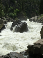 River raging through the canyon
Sioux Charley Lake
The right branch in the highway (mentioned above) leads to the parking lot and trailhead for Sioux Charley Lake. Hikers travel alongside the Stillwater River on Trail #24 for 1/4 mile to the wilderness boundary and then another 2.5 miles to Sioux Charley Lake. This is a remarkable excursion with pristine views of the Beartooths on all sides, well worth the effort. Trail length is 6 miles round trip with a 600 feet elevation gain.
The Stillwater River courses through a rock canyon as the hike begins, boiling and churning over big boulders the first mile of the walk. Soon the river evens out, giving fishermen easier access to the river. Hikers continue to gain elevation as they travel through timber and wildflower-filled meadows, approaching Sioux Charley Lake. At about the 2.5 mile point, the trail reaches its highest point and Sioux Charley can be seen down below.
 Sioux Charley
This lake could probably best be described as a wide spot in the river. Be sure to look for the trail through the pines diverging off toward the river from the main trail, as there is not a sign marking the lake. Regardless of the size of the lake, the hike in is very much worth experiencing.
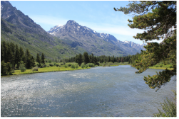
The Stillwater River Trail is a also popular destination for backpackers who want to explore the depths of the Beartooth Mountains.
The Stillwater River Trail is a also popular destination for backpackers who want to explore the depths of the Beartooth Mountains.
Campground Information
Find complete info for the following campgrounds.
Find complete info for the following campgrounds.